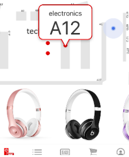
The feature, described as a “GPS for your shopping cart,” uses a system of in-store beacons and Bluetooth technology to show customers their current location on the map as they move through the aisles. Shoppers can use the map to find the next item on their shopping list. For example, Target customers can already create a list on the store’s app. While shopping they can click on that item and the new map will show them exactly where it is located in their local store.
Integrating a GPS-like map into its app isn’t entirely surprising for Target. For years, the retailer has experimented with mapping stores to make shopping easier for customers. For instance, in Nov. 2014, Target issued an update to its app that told shoppers what’s in stock and where to find those items inside the store. That feature was more broad, showing customers the aisle the item was located in, but not directions to that area.
1 comment:
Post a Comment